
The site of Wharram Percy, situated on the Yorkshire Wolds, is one of the most extensively studied deserted villages in the country, even though only an estimated 6.5% of the site has been excavated. This site was one of the first villages chosen to be studied by Maurice Beresford after a visit in 1948. Excavations began in 1950 and the first two seasons of excavations at the site showed the potential for future study. These early excavations did not necessarily have archaeological rigour, but the appearance on the scene of recent graduate archaeologist John Hurst in 1952 saw the forging of a partnership that lasted over 50 years, and the development of archaeological techniques at Wharram and in the greater field of medieval archaeology. This partnership also saw the formation of the Deserted Medieval Villages Research Group, and much of the research generated by this group forms the backbone to this website.
This section of the website provides a physical description of Wharram, outlines a brief history of the village, and presents an overview of the excavations. The results of the excavation have now been published in a series of 13 volumes (see below), and while this section does not replace any of these published sources it does provide an overview of this historic site and project. The site is publically accessible, with access off the B1248 Beverley to Malton road. A car park is situated 750m from the site, with a walk to the site down a steep slope. A guide book for the site is available from English Heritage or from one of the other English Heritage properties close by, such as Helmsley Castle (Oswald 2013). Wharram Percy also has its own record on this website in Yorkshire (East Riding) but this section expands on this description.
The Medieval Village
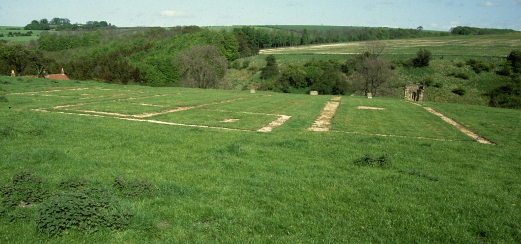
A roughly north-south hollow way is the focus of the settlement at Wharram Percy. There is a complex history of the development of the settlement and not all features present at the site were in use at the same time. At the northern end is the manorial complex known as the North Manor, as well as a row of six tofts and crofts (North Row). On the western side of the hollow way were two sections of tofts and crofts (West Row north and West Row south) and the location of another manorial complex, the South Manor. In the northern area, to the east of the hollow way, was a further row of tofts and crofts (East Row) and in the south is the location of the post-medieval farms, the vicarage, church and churchyard, and the mill pond.
In total there would seem to be around 40 peasant house plots at Wharram, but it is unsure if all would have been occupied at the same time. Excavation of houses at Wharram has shown evidence of longhouses typical of the period, however their construction has been a matter of interpretation (Andrews and Milne 1979, Wrathmell 1989). From the start of the Wharram Research Project one of the ideas that had been postulated was that there was evidence for planning. As the project continued it became clear that there were probably several events that saw planned elements added to the village structure (Hurst 1971: 127, 1980).
The West Row (south) possibly consisted of nine tofts but there is no evidence of adjoining crofts (Oswald 2012: 39). It is suggested that the row was in place by the time the South Manor house was built so that dates it from before c. 1180, and was probably the first area of the nucleated village to be settled (Oswald 2012: 39). The West Row (north) was probably laid out at the time the South Manor was created in the twelfth century and consisted of six tofts (Oswald 2012: 37). The North Row was in existence before 1254, as the changes to the North Manor at this point, destroyed at least one toft (Oswald 2012: 35). At its creation it would seem that the row consisted of six tofts and crofts.
The East Row was the last of the units to be added to the settlement (Oswald 2012: 33). It seems that it was placed over what had been the village green. It has been suggested that the context for this expansion was the Percy Family acquisition of the majority of the landholdings and the expansion of the North Manor House (Oswald 2012: 33). The East Row is made up of at least eleven tofts and crofts.
The North Manor site has not been extensively excavated and most of what we know about the site comes from earthwork surveys (Rahtz and Watts 2004). Even so, there was the possibility of at least three different phases of activity (Oswald 2012: 26-30). Initially a hall with kitchen and solar block with an adjacent barn is suggested. This is then expanded with the addition of a courtyard hall to the east and a more complex entrance way to the surrounding enclosure, removing at least one peasant house plot. Finally after the manor house is abandoned a peasant farmstead is built on the site.
Excavations at the South Manor revealed an elaborate stone-built undercroft interpreted as part of a solar block (Andrews and Milne 1979, Stamper and Croft 2000, Oswald 2012: 31-3). A number of interpretations have been presented for how this high status stone-built building fitted into other buildings in its vicinity. These have included a large timber built hall built at right angles with this undercroft (Beresford and Hurst 1990). Alternatively a timber structure to the east could be suggested but on scant evidence (Stamper 2000: 201, Everson and Stocker 2012: 264-5). When the Percy’s acquired both manors in 1254 the site was abandoned and converted into further peasant tofts.
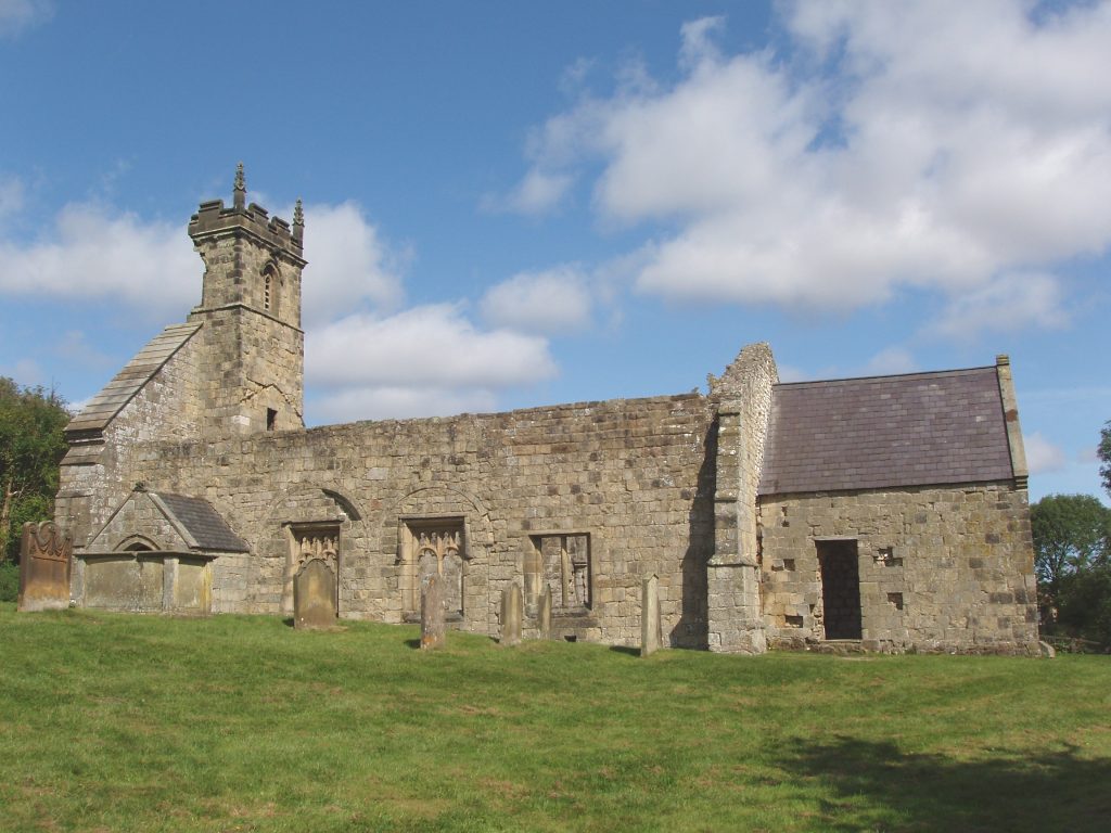
The church had a long developmental history. From an initial small timber building, it was replaced in stone in the eleventh century and continued to grow with a much larger nave introduced in the twelfth century, and side aisles added from the late-twelfth century. However the phases of expansion, as with all of the evidence at Wharram Percy, have been debated (Bell et al. 1987: 1, Stocker 2012: 241). The church not only served Wharram Percy but also four other neighbouring villages; Raisthorpe, Towthorpe, Burdale, and Thixendale. So even when the population at Wharram declined, there were still parishioners who attended the church. However of the other villages in the parish, only Thixendale survives today, and when it gained its own church in 1868, the congregation of Wharram was solely made up of a scatter of farmsteads (Beresford 1987). The gradual decline of the population in the parish can be seen with the gradual reduction in the size of the church. Side aisles were removed and blocked off and the size of the chancel was reduced.
Excavations have also revealed a series of post-medieval farmhouses in the centre of the village, in the area of the surviving cottages. Here, an initial structure built c. 1674 was replaced by a more substantially built structure in 1807 (Oswald 2013: 3). To the north a range of farm buildings around a courtyard has been constructed from the 1770s, and the existing cottages formed part of this enclosure. A range of vicarages had also been built between the farm and the church, with the earliest dated to c. 1327 (Oswald 2013: 4). This vicarage had a detached barn. In 1546 additions were made to the vicarage but a fire in 1533 destroyed both it and the barn. A new vicarage was constructed the following year but by 1604 was in disrepair. By 1674 yet another new vicarage had been built and a further structure was constructed in the early-eighteenth century (Oswald 2013: 5).
History of Wharram Percy
The history of Wharram Percy does not start and end in the medieval period. There is extensive evidence of earlier occupation at the site. There is evidence for Iron Age farm enclosures, a major phase of Roman activity with an enclosed farm, and middle Saxon activity, though the nature of this is debated, before the formation of the village (see Wrathmell 2012a, Chapter 11). The exact date of the formation of the nucleated village at Wharram Percy is also somewhat debated, but sometime between AD 850-950 the landscape was reorganised and the village began to be formed (Wrathmell 2012b, Oswald 2013, Everson and Stocker 2012). A small wooden church was placed in the valley bottom. By 1200, the tofts and crofts on the west side of the main route through the village had been established and at least one manor house (South Manor) was present. By 1254 most of the land at Wharram was in the hands of Peter Percy, and it is possibly at this point further tofts and crofts are laid out to the north and east of the route way. The South Manor was also demolished and the focus of the manorial centre shifted to the North Manor. This extension of the number of tofts and crofts increased the potential number of properties in the village to around 40. In 1368 there are about 30 farmhouses recorded but some do not seem to have tenants (Wrathmell 2010: 110). By the 1377 Poll Tax 30 tax payers are recorded, although the sum they paid is very low.
The end to Wharram Percy in many ways is much better documented than its living phases. By 1435 the village had already reduced in size. Only 16 houses are recorded, and these are once again recorded in 1458 (Wrathmell 2010: 110). In 1517 the commission investigating enclosure of arable land recorded that sometime after 1488, four houses had been destroyed (Wrathmell 2010: 110, Leadam 1892: 287-86). The details of this depopulation and the conversion of the arable land at Wharram Percy is given more flesh with two legal cases. One of the cases occurred in 1555 when William Firby, vicar at Wharram, brought out a claim against the former vicar, Marmaduke Atkinson. He claimed that in 1553 the vicarage and its barn burnt down and although Atkinson had rebuilt the vicarage, he had not rebuilt the barn (Wrathmell 2010: 111). Atkinson claimed that it was not worth rebuilding it as the small amount of glebe land belonging to the church did not warrant it. Witnesses that were called in the case paint a picture of the conversion of much of the village to pasture. Robert Pickering of Raisthorpe, in his response to questions said that ‘the town was laid to grass which is 28 years since’ (Wrathmell 2010: 112). It thereby gives a date of 1527 for the final conversion of the village fields to pasture. So for Wharram Percy we have a clear idea on its desertion, which cannot be said for all the settlements on this website. We see the gradual reduction in population through the fifteenth and early-sixteenth century, with the conversion of the arable land to pasture seeming to be the driving force which may have come on the back of a weakening of the population through the various challenges of the fourteenth century.
But the site of Wharram Percy was never fully deserted until the twentieth century. The church was still in use until 1870, and then intermittently until 1949, a succession of vicarages were constructed up to the eighteenth century, and a number of post-medieval farms occupied the sites, with the small row of cottages still standing today which had been part of a late eighteenth-century farmyard. The last residents of these left these cottages in 1974. The site was taken fully into Guardianship in 1974 by the Department of the Environment, now under the protection of English Heritage.

Outline of Research at Wharram
Excavations under the auspices of the Wharram Research Project were undertaken between 1950 and 1990 for three weeks a year. The initial excavations in the 1950s and 1960s were interested in uncovering the plans of domestic peasant housing. The main areas studied were those of Area 6 and Area 10 (Andrews and Milne 1979, Wrathmell 1989). In 1955 during the excavations in Area 10 it was found that in an earlier phase this had been the location of a manor house (South Manor). This was the first of many surprises that occurred over the 40 years of the project. In the 1960s the project expanded and the next focus was on the church which by this stage was in a very bad state of repair. Excavations where carried out between 1962 and 1974 and saw the complete investigation of the church and part of the surrounding churchyard (Bell et al. 1979, Mays et al 2007, Rahtz and Watts 1983). This was the first complete excavation in England of a parish church (Croft 2011: 233). After the site was taken into state Guardianship it was then possible to extend excavation across the entire site. The next stages saw investigation of the mill dams and the medieval and post-medieval parsonages (Harding and Wrathmell 2007, Treen and Aitkin 2005). By the 1980s a much larger remit of questions was formed which included the study of the wider landscape (Hayfield 1987, Rahtz et al. 1986). The ongoing excavations until 1990 reflect this more holistic approach to the village, with the work of the last season including the Roman farmstead at the north of the site, the mid-Saxon settlement in the West Row (north), and the succession of Post-Medieval Vicarages (Rahtz and Watts 2004, Milne and Richards 1992, Harding and Wrathmell 2010). That is not to say excavations were not carried out on the medieval village during the later phases – they were, with excavations trying to resolve issues from earlier work such as the nature of the South Manor (Stamper and Croft 2000).
The final season of excavations in 1990 was not the end of the research at Wharram. Further detailed topographic and geophysical surveys followed over the period of 2001-2002, and excavations were carried out on the north of the site in 2005 (Oswald 2012, Linford et al. 2012, Roskams 2012).
The Work at Wharrram not only had an impact on the knowledge of the site, but also the new practice of medieval archaeology, and more particularly open-area excavation, was trialled, tested and formulated at the site (Hurst 1971: 86-89, Croft 2011: 233, Wrathmell 2012a: 1.) Over the forty years of summer excavations, the project also contributed to the discipline of archaeology in other ways. In some ways it has been seen as a ‘social experiment’ with an estimated 5000 people having worked at the site (Croft 2011: 236, 239-241). If an army marches on its stomach, an archaeological project survives or fails on the provision of timely and substantial meals (Croft 2011: 238). The history of the catering at Wharram has also warranted much discussion and much emulation in archaeological circles (Watt 1990, Croft 2011). Another legacy has been the generations of archaeologists who were trained and honed their skills during the summer excavations, including one of the directors of this website.
The research at Wharram has not only shown the way in the key developments of medieval archaeology, but it also reflects the ever changing interpretations and ideas on medieval settlement. This is neatly illustrated by the final volume of publication, named in short Wharram XIII. Here a single narrative of the story of Wharram is not presented, and it sets out quite clearly at the start – this is not the history of Wharram Percy, but a history of Wharram Percy (Wrathmell 2012a: xi). Within this volume alternative interpretations are presented on a number of topics such as the development of the middle Saxon occupation, and the drivers of the formation of the village. This in essence shows us how far the debate of medieval rural settlement origins and development has come, but also how far there is still to go. Wharram Percy is long from dead – it has much to contribute to current arguments and debates on medieval settlement, and it still has secrets to be revealed.
Bibliography
Andrews, D.D. and G. Milne 1979. Wharram. A Study of Settlement on the Yorkshire Wolds, I. Domestic Settlement 1: Areas 10 and 6. Leeds: Society for Medieval Archaeology Monograph 8.
Bell, R.D., M.W. Beresford and others 1987. Wharram. A Study of Settlement on the Yorkshire Wolds, III. Wharram Percy: The Church of St Martin. Leeds: Society for Medieval Archaeology Monograph 11.
Beresford, M.W. 1987. ‘The Documentary Evidence’, in R.D. Bell, M.W. Beresford and others Wharram. A Study of Settlement on the Yorkshire Wolds, III. Wharram Percy: The Church of St Martin: 5-46. Leeds: Society for Medieval Archaeology Monograph 11.
Beresford, M.W. and J.G. Hurst. 1990. Wharram Percy: Deserted Medieval Village. London: Batsford.
Croft, B. 2011. ‘Growing up at Wharram Percy’, in J. Schofield (ed.) Great Excavations: Shaping the Archaeological Profession: 231-246. Oxford: Oxbow Books.
Everson, P. and D. Stocker 2012. ‘Who at Wharram?’, in S. Wrathmell (ed.) Wharram. A Study of Settlement on the Yorkshire Wolds, XIII. A History of Wharram Percy and Its Neighbours: 262-277. York: York University Publications 15.
Harding, C., E. Marlow-Mann and S. Wrathmell 2010. Wharram. A Study of Settlement on the Yorkshire Wolds, XII. The Post-Medieval Farm and Vicarage. York: York Archaeology Publications 14.
Hayfield, C. 1987. Wharram. A Study of Settlement on the Yorkshire Wolds, V. An Archaeological Survey of the Parish of Wharram Percy, East Yorkshire 1: the Evolution of the Roman Landscape. Oxford: British Archaeological Research Report 172.
Hurst, J.G. 1971. ‘A Review of Archaeological Research (to 1968)’, in M.W. Beresford and J.G. Hurst (eds) Deserted Medieval Villages: Studies: 76-144. London: Lutterworth Press.
Hurst, J.G. 1980. ‘The Topography of Wharram Percy Village’, in B.K. Roberts and R.E. Glasscock (eds) Villages: Fields and Frontiers: 3-20. Oxford: British Archaeological Reports International Series 185.
Leadam, I.S. 1892. The Inquisition of 1517. Inclosures and Evictions Part 1. Transactions of the Royal Historical Society 6: 167-314.
Linford, P., N. Linford and A. David 2012. A New Geophysical Survey of Wharram Percy’, in S. Wrathmell (ed.) Wharram. A Study of Settlement on the Yorkshire Wolds, XIII. A History of Wharram Percy and Its Neighbours: 44-54. York: York University Publications 15.
Mays, S., C. Harding and C. Heighway 2007. Wharram. A Study of Settlement on the Yorkshire Wolds, XI. The Churchyard. York University Archaeology Publications 13.
Milne, G. and J.D. Richards 1992. Wharram. A Study of Settlement on the Yorkshire Wolds, VII. Two Anglo-Saxon Buildings and Associated Finds. York: York University Publications 9.
Oswald, A. 2012. ‘A New Earthwork Survey of Wharram Percy’, in S. Wrathmell (ed.) Wharram. A Study of Settlement on the Yorkshire Wolds, XIII. A History of Wharram Percy and Its Neighbours: 23-44. York: York University Publications 15.
Oswald, A. 2013. Wharram Percy Deserted Medieval Village. London: English Heritage.
Rahtz, P.A and L. Watts 1983. Wharram. A Study of Settlement on the Yorkshire Wolds, II. Wharram Percy. The Memorial Stones of the Churchyard. York: York University Publications 1.
Rahtz, P.A. and L. Watts 2004. Wharram. A Study of Settlement on the Yorkshire Wolds, IX. The North Manor Area and North-West Enclosure. York: York University Publications 11.
Rahtz, P.A., C. Hayfield and J. Bateman 1986. Wharram. A Study of Settlement on the Yorkshire Wolds, IV. Two Roman Villas at Wharram le Street. York: York University Publications 2.
Roskams, S. 2012. ‘The 2005 Excavations of the North-West Enclosure’, in S. Wrathmell (ed.) Wharram. A Study of Settlement on the Yorkshire Wolds, XIII. A History of Wharram Percy and Its Neighbours: 57-62. York: York University Publications 15.
Stamper, P.A. 2000. ‘The Post-Conquest Evidence’, in P.A. Stamper and R.A. Croft (eds). Wharram. A Study of Settlement on the Yorkshire Wolds, VIII. The South Manor Area: 201-203. York: York University Publications 10.
Stamper, P.A. and R.A. Croft 2000. Wharram. A Study of Settlement on the Yorkshire Wolds, VIII. The South Manor Area. York: York University Publications 10.
Stocker, D. 2012. ‘A New Understanding of the Church Fabric’, in S. Wrathmell (ed.) Wharram. A Study of Settlement on the Yorkshire Wolds, XIII. A History of Wharram Percy and Its Neighbours: 240-262. York: York University Publications 15.
Treen, C. and M. Atkin 2005. Wharram. A Study of Settlement on the Yorkshire Wolds, X. Water Resources and their Management. York: York University Publications 12.
Watt, J. 1990. Wharram Recipes Including a Short History of Wharram Catering. Private publication.
Wrathmell, S. 1989. Wharram. A Study of Settlement on the Yorkshire Wolds, VI. Domestic Settlement 2: Medieval Peasant Farmsteads. York: York University Publications 8.
Wrathmell, S. 2010. ‘The Desertion of Wharram Percy Village and its Wider Context’, in C. Dyer and R. Jones (eds) Deserted Villages Revisited: 109-120. Hatfield: University of Herefordshire Press.
Wrathmell, S. 2012a. Wharram. A Study of Settlement on the Yorkshire Wolds, XIII. A History of Wharram Percy and Its Neighbours. York: York University Publications 15.
Wrathmell, S.2012b. ‘Dating the Formation of the Medieval Village’, in S. Wrathmell (ed.) Wharram. A Study of Settlement on the Yorkshire Wolds, XIII. A History of Wharram Percy and Its Neighbours: 203-206. York: York University Publications 15.