
Introduction
This section includes a range of information on the settlement, including the location of further information, the presumed date of depopulations, links to official records, lists of investigations undertaken at the site, and any maps, plans or photographs of the site.
Alternative names
If there is a significantly different spelling of the place-name or if an alternative name altogether has been suggested then it is presented here.
Presumed date of depopulation
A date range is suggested for the depopulation of the settlement if it can be ascertained from the available evidence.
NMR number
This is the National Monuments Records number. The National Monument Record is the Historic England archive of information on architectural and archaeological monuments and sites. The record is based in Swindon but a summary of the record is available via the Heritage Gateway website: https://www.heritagegateway.org.uk/gateway/ These used to be available via Pastscape but now can be accessed by Heritage Gateway and are part of the Historic England Research Records database. There will be references to Pastscape in the database until all these can be edited to their new location.
HER number
This is the record number on the local Historic Environments Record (HER). This has been found either by using the online catalogues at Heritage Gateway (http://www.heritagegateway.org.uk/Gateway/) or from data provided by the HER. The record number is prefixed by a code to indicate in which of the local records it is stored – see the Glossary for a list of these codes. These records can be consulted in person at the relevant office. See http://www.heritagegateway.org.uk/gateway/chr/default.aspx for a list of these offices. If the record is blank this does not definitely mean that the site is not recorded on the HER record, but that further research may be required. There are also a number of HERs for which the information has yet to be acquired. These are: Chichester, Dudley, Nottingham, Plymouth, Portsmouth, Sandwell, Solihull, Southend, and Stoke-on-Trent.
Investigation history
Here is listed any field work or visits that have taken place on the site. References to this fieldwork are given if available. Some of these records have come from the National Monuments or Historic Environments Records.
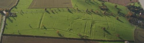
Cartographic or photographic records
A list of published or archive maps and photographs of the site. These include references to aerial photographs of the site. Many of these are kept in the National Monuments Record office in Swindon. The codes for aerial photographs are given as accurately as possible, but different institutions have different ways of presenting their data. If a date for the photograph is given this is presented.
Site status
This indicates whether the site is a Scheduled Ancient Monument and gives its designation number. It is also noted if a monument is scheduled in the nearby area, which may include the area of the deserted settlement but this has not been included within the designation. A Scheduled Ancient Monument is given certain protection by law.
x coordinate
A six figure easting for the grid reference which can be used to plot the settlement location using Geographical Information Systems.
Y coordinate
A six figure northing for the grid reference which can be used to plot the settlement location using Geographical Information Systems.
Bibliography
A list of publications which mention the site.
See also
Presented here are direct web links to records about this site. Primarily it lists the direct link to the record on Heritage Gateway and Open Domesday, but may include other external websites.