
Description
A total of 15 deserted settlements appear on the 1968 Gazetteer. In 1954 Beresford had published a list of 13 settlements, however one of these was dismissed by 1968, Silverley. In 2009 Susan Oosthuizen published an updated list of settlements in Cambridgeshire (excluding the Isle of Ely) (Oosthuizen 2009). This made a clear distinction between deserted and shifted settlements. This added a further 43 deserted and 24 shifted sites to the list. Here Oosthuizen considered issues of distribution of settlement and causes for desertion. She noted that the boundary between the Central Province of settlement characteristics and the Eastern Province runs through the region. In the Central Province (mainly west of the River Cam), settlement is mainly characterised by nucleated settlements, with evidence of polyfocal settlements in some areas (Oosthuizen 2009: 14). On the eastern side of this boundary and the River Cam is a landscape characterised by more dispersed settlement. Although the article was mainly published to present the new list of sites for Cambridgeshire, she does postulate a number of interesting ideas on the future study of settlement in the region, looking more closely at the settlement hierarchy.
Excavations
Much of the early work as well as that by Oosthuizen have originated from the Continuing Education section of Cambridge University. One well studied settlement is that of Clopton. Here an early study of the site gave a full account of the surviving historical evidence and the enclosure of the common lands in the early sixteenth century (Palmer 1933). Excavations in the 1960s revealed a range of evidence including the church, churchyard with nearly 100 burials excavated, as well as building structures (Alexander 1968). Other excavations in Cambridgeshire include those at Childerley which revealed evidence of house platforms and pottery as well as showing that although damaged had occurred during ploughing some remains were still intact (RCHME 1968).
A number of surveys of deserted sites have been undertaken during extra mural courses since the 1970s. These included work at Castle Camps (Taylor 1973) and Croxton (Brown and Taylor 1993). These two surveys give contrasting examples of desertion.
County Boundaries
The pre-1974 county of Cambridgeshire has seen only limited changes to its boundary with a decrease in area to Huntingdonshire. The modern county now includes the old county of Huntingdonshire and is divided between the county of Cambridgeshire and the unitary authority of Peterborough.
Documentary Evidence
The 1334 record is complete however a number of settlements recorded in Cambridgeshire had moved to Hertfordshire and Suffolk by the pre-1974 counties, and a number of settlements recorded in Essex and Huntingdonshire in 1334 were in pre-1974 Cambridgeshire (Glasscock 1975). In 1377 there is a near full record, with some missing names that can be guessed at when cross-referenced to the 1334 Lay Subsidy (Fenwick 1998: 68). There are no returns for the 1379 or 1381 Poll Taxes. In the sixteenth century there are gaps in the records for 1525 (Sheail 1998: 70). For the later subsidy the figures for 1545 have been used for most hundreds apart from Northstow and Papworth when the 1543 figures are presented. Part of the Diocesan Return for 1563 survives in the return for Diocese of Ely, but the eastern part of the county lies within the Diocese of Norwich and these records are lost, however survive for the 1603 Return (Dyer and Palliser 2005).
The issue of charting the history of settlements in Cambridgeshire from their documentary evidence has been noted by Taylor (1973: 43). The figures not only record a single nucleated village, but also a wide range of farms and hamlets. In some cases eventually the population moves to one of the other settlements within the parish, and hence there appears to be no overall reduction of population in the taxation record, but there is evidence of settlement desertion in the landscape (Taylor 1973: 43).
County Records
The county is covered by the Cambridgeshire HER and the Peterborough HER. Cambridgeshire HER is accessible via Heritage Gateway. Peterborough HER can be accessed via their own website.
References
Alexander, J.A. 1968. ‘Clopton: the Life-Cycle of a Cambridgeshire Village’, in L.M. Munby (ed.) East Anglian Studies: 48-70. Cambridge: Heffer and Sons.
Brown, A.E and C.C. Taylor 1993. ‘Cambridgeshire Earthwork Surveys VI’, Proceedings of the Cambridge Antiquarian Society 82: 101-111.
Dyer, A. and D.M. Palliser 2005. The Diocesan Population Returns for 1563 and 1603. Oxford: Oxford University Press.
Fenwick, C.C. 1998. The Poll Taxes of 1377, 1379 and 1381: Part 1: Bedfordshire-Leicestershire. Oxford: Oxford University Press.
Glasscock, R.E. 1975. The Lay Subsidy of 1334. London: Oxford University Press.
Palmer, W.M. 1933. ‘A History of Clopton, Cambridgeshire’, Proceedings of the Cambridge Antiquarian Society 33: 3-65.
Oosthuizen, S. 2009. ‘The Deserted Medieval Settlements of Cambridgeshire: A Gazetteer’. Medieval Settlement Research 24: 14-19.
RCHME. 1968. An Inventory of the Historical Monuments in the County of Cambridgeshire: Volume I. West Cambridgeshire. London: RCHME: 44-47.
Sheail, J. 1998. The Regional Distribution of Wealth in England as Indicated in the 1524/5 Lay Subsidy Returns: Volume One. London: List and Index Society.
Taylor, C. 1973. ‘Cambridgeshire Earthwork Surveys’, Proceedings of the Cambridge Antiquarian Society 64: 35-43.
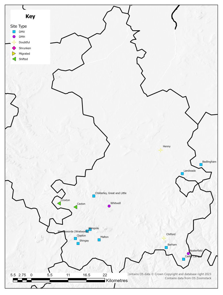
List of deserted villages recorded in 1968
- Badlingham
- Barham
- Castle Camps
- Caxton
- Childerley, Great and Little
- Chilford
- Clopton
- Croxton
- Henny
- Landwade
- Malton
- Nosterfield
- Shingay
- Werateworde (Wratworth)
- Whitwell
- Wimpole