
Description
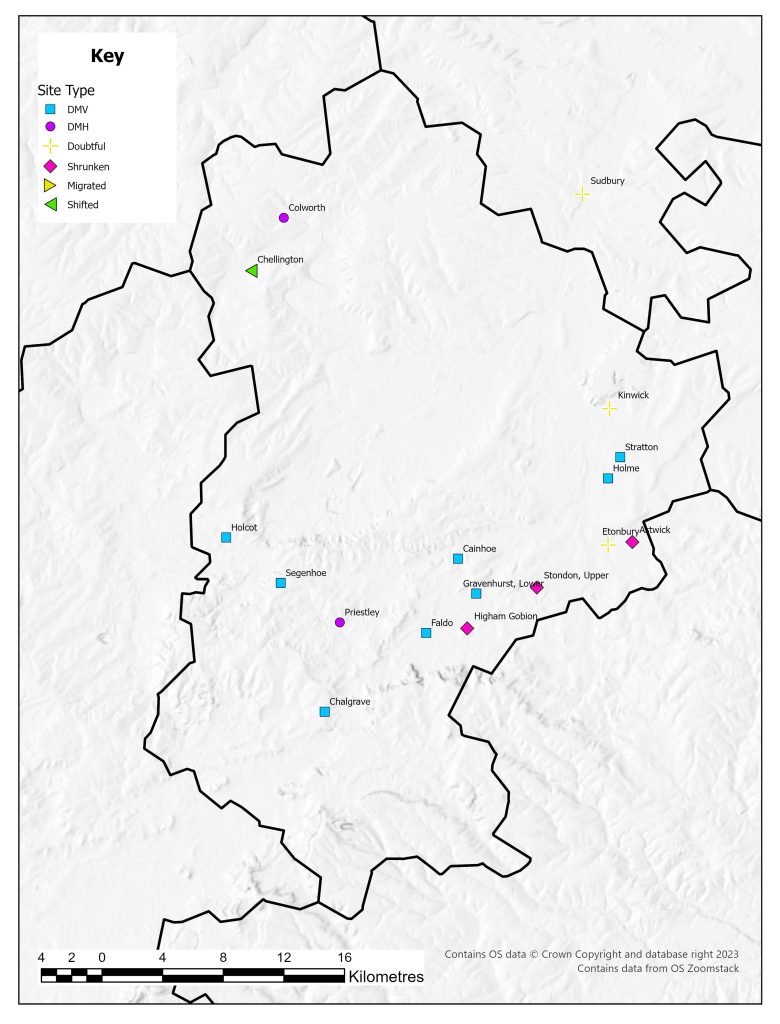
Beresford had listed two certain deserted villages in 1954, with a further five as possibilities (Beresford 1954: 338-339). There were 18 deserted sites recorded in the 1968 Gazetteer. Now on the Bedfordshire Historic Environment Record there are over 200 sites classified as deserted settlements. There has been little wholesale investigation of the deserted settlements of Bedfordshire but a number of projects have been invaluable in our understanding, not just of medieval Bedfordshire but also of medieval settlement in general: the research project looking at settlement development in the East Midlands (Lewis et al. 2001); and the excavations at the deserted site of Stratton.
The settlement pattern within medieval Bedfordshire is diverse. In some areas there is clear evidence of nucleated settlement, in others the landscape comprises dispersed settlement with some nucleation (Edgeworth 2007: 99). In their study of the East Midlands, Lewis, Mitchell-Fox and Dyer (2001: 57-58) divide Bedfordshire into three zones. In the claylands to the north of Bedford there is a zone of dispersed settlement with forms of settlement including interrupted rows and isolated farmsteads. In the south of the county more variety is present with small clusters, polyfocal settlements, short regular rows, interrupted rows, and numerous isolated farmsteads with occasional areas of nucleations. In north-west of the county the pattern is dominated by nucleated settlement. This shows the diversity of the settlements of Bedfordshire into which the pattern of desertion fits.
A small overview of some of the deserted villages in Bedfordshire has been undertaken by Dick Dawson (2007). This includes a number of the sites on the 1968 Gazetteer of deserted villages. These accounts not only focus on the evidence for settlement but also notable residents of the area. One downside is the lack of references or indication of the nature of the sources of some of the information, as a number of the tales seem to be folk memory rather than substantive evidence-based theories.
Excavations
A small number of sites have been excavated in Bedfordshire. At Higham Gobian excavations in 1954 revealed a wall and pottery (Bedfordshire HER No. 773). At Stratton extensive excavations have shown the development of settlement from Saxon origins that continued to shift focus eastwards until the seventeenth century (Edgeworth 2007: 108). This pattern of shifting settlements has also been noted for Potton and suggested for Chellington (Edgeworth 2007: 100). This evidence would suggest a more complex settlement development and that a site such as Stratton may suggest a typical deserted medieval village with a regular layout is in fact only one stage in a more fluid process of development (Edgeworth 2007: 108).
County Boundaries
There have been many changes at the edges of the county with exchanges with Buckinghamshire, Cambridgeshire, Hertfordshire, , Huntingdonshire, and Northamptonshire. The county now includes the unitary authorities of Bedford and Luton and the county of Central Bedfordshire. Due to its location Bedfordshire has sometimes been classed as part of the South Midlands, sometimes the East Midlands, but is now administered by English Heritage as part of the East of England Region (Oake 2007: 1).
Documentary Evidence
The original 1334 record is not complete for the county, but has been supplemented with details from 1336 as these have been shown to be based on the 1334 Subsidy (Glasscock 1975). Very few tax records survive for the fourteenth-century poll taxes. There are no lists for 1377 or 1381, and a very fragmentary record survives for 1379 (Fenwick 1998). This fragmentary survival continues with the sixteenth-century lay subsidies with Bedfordshire having the poorest coverage of any county in the country (Sheail 1998: 61). The figures for the 1543 Lay Subsidy have not been published and hence are left blank here. The Diocesan Returns for 1563 for Bedfordshire can be found in the Diocese of Lincoln and survive in full (Dyer and Palliser 2005: 178).
Country Records
There are two HERs which cover the county. The Central Bedfordshire and Luton HER and the Bedford Borough HER. The records of both can be viewed via Heritage Gateway.
References
Beresford, M.W. 1954. The Lost Villages of England. London: Lutterworth Press.
Dawson, D. 2007. Lost Villages of Bedfordshire. Hitchin: Streets Publishers.
Dyer, A. and D.M. Palliser 2005. The Diocesan Population Returns for 1563 and 1603. Oxford: Oxford University Press.
Edgeworth, M. 2007. ‘Anglo-Saxon and Medieval Bedfordshire’, in M. Oake, M. Luke, M. Dawson, M. Edgeworth and P. Murphy (eds) Bedfordshire Archaeology: Research and Archaeology: Resources Assessment, Research Agenda and Strategy: 87-118. Bedford: Bedfordshire Archaeology Monograph 9.
Fenwick, C.C. 1998. The Poll Taxes of 1377, 1379 and 1381: Part 1: Bedfordshire-Leicestershire. Oxford: Oxford University Press.
Glasscock, R.E. 1975. The Lay Subsidy of 1334. London: Oxford University Press.
Lewis, C., P. Mitchell-Fox and C. Dyer 2001. Village, Hamlet and Field: Changing Medieval Settlements in Central England. Macclesfield: Windgather Press.
Oake, M.K. 2007. ‘Introduction and Background’, in M. Oake, M. Luke, M. Dawson, M. Edgeworth and P. Murphy (eds) Bedfordshire Archaeology: Research and Archaeology: Resources Assessment, Research Agenda and Strategy: 1-6. Bedford: Bedfordshire Archaeology Monograph 9.
Sheail, J. 1998. The Regional Distribution of Wealth in England as Indicated in the 1524/5 Lay Subsidy Returns: Volume One. London: List and Index Society.
List of deserted villages recorded in 1968
Site names in italics are unlocated and so do not appear on the VIllage Explorer. For the unlocated sites, click on their names and it will take you to the basic information about this village.
- Astwick
- Cainhoe
- Chalgrave
- Chellington
- Colworth
- Cudessane
- Etonbury
- Faldo
- Gravenhurst, Lower
- Higham Gobion
- Holcot
- Holme
- Kinwick
- Priestley
- Segenhoe
- Stondon, Upper
- Stratton
- Sudbury