
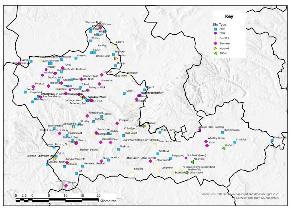
Description
In 1954 seven villages were identified by Beresford in Berkshire. These included Fulscot were depopulation had been reported in 1517 and Seacourt were excavations had been carried out. The other five settlements were classed as shrunken (Beresford 1954: 340). In 1962 the first attempt at constructing a county-wide list produced 36 sites (Beresford and Hurst 1962). All of the sites listed in 1962 appear on the 1968 Gazetteer by which time the list of sites in the county had risen to 43. On this website Berkshire is presented with as full a data set as possible and is offered as an example of the future development of this resource. The total number of sites now listed is 123, an increase by 79, with one of the original list now classed as two separate records (Betterton). These additions have been identified from local research, records on the NMR and HER as well as other sources such as the research of John Brooks (1982). Of course this does not preclude settlements that have yet been identified and the project has not undertaken a full analysis of every individual record in the county. So for Berkshire there has been a 186% increase in recorded settlements since 1968. However not all these settlements can be classed as true deserted medieval villages – and the classification of sites does show a changing picture. In total, of the 123 sites, 50 are classed as DMV (40.65%), 8 are classed as deserted medieval hamlets (6.5%), 30 show evidence of shrunken settlement (30%), three indicate shifted settlement (2.44%) and five are migrated settlements (4.07%). Finally 27 settlements on this list have been classified as doubtful (21.95%).
This reflects some of the reclassification of the sites from the original Gazetteer. From those 43 listed in 1968 – 36 remain as DMVs, one is now classified as a shrunken settlement and six have now been labelled as doubtful. The 186% increase in sites does not reveal an equivalent increase in DMVs. An additional 14 sites have now been classified as DMVs, but the majority of the recent additions have been the smaller settlements, shrunken and a greater number of dismissed settlements. Many settlements may be listed as deserted on local and national records but they hold no evidence to support this – nearly 22% in the case of Berkshire.
| Classification | 1968 Gazetteer | 2014 update |
| Deserted Medieval Village | 36 | 14 |
| Deserted Medieval Hamlet | 0 | 8 |
| Shrunken | 1 | 29 |
| Shifted | 0 | 3 |
| Migrated | 0 | 5 |
| Doubtful | 6 | 21 |
| Totals | 43 | 80 |
In all then for Berkshire there are now 58 settlements that are classed as deserted (both villages and hamlets), only really a small increase in number since 1968 (34%). But what have increased dramatically are those that are identified as shrunken, but also those ones that are now not considered to have been deserted or the centre of a nucleated settlement.
Berkshire, as with a number of other counties has benefited since 1968 from intensive local study. Most notably, John Brooks produced a thesis looking especially at deserted settlement in north Berkshire (1982). Nevertheless, classification of many of the Berkshire sites in the database is still hampered by lack of research or field investigation. For example, of the 50 DMVs in the database 21 currently lack any field evidence in the form of earthworks of excavated remains. In such cases, where sites are supported only by documentary evidence for former large medieval populations, the possibility remains that these communities did not live in nucleated settlements.
Indeed, even from the early lists, Beresford and Hurst warn of caution in Berkshire when looking for settlements that appear in medieval documentation on the ground (Beresford and Hurst 1962: 94). They highlight the dispersed nature of the settlement in the area and that ‘it is impossible to say confidently that the appearance of a place-name… necessarily implies a nucleated settlement which has since been abandoned’ (Beresford and Hurst 1962: 94). Berkshire is a county of contrast with areas of nucleated and dispersed settlement (Astill 2006), as well as zones where the two types of settlement co-existed. As such the county crosses different landscape character zones and is an excellent place to study regional variety. The geographical distribution of the DMV dataset may therefore repay closer study as the evidence for individual sites is refined. For the moment it can be observed that the majority of DMVs and shrunken sites are found in the west and north-west of the county, although this probably largely reflects the greater medieval settlement density in this part of the county, especially compared against other areas such as the non-riverine interior of east Berkshire.
Excavations
Limited excavations have taken place in Berkshire, and of those that have, few have been fully published. One of the earliest excavations in the county is that at Seacourt, threatened with destruction from the Oxford Western by-pass (Bruce Mitford 1940, Biddle 1961-2). These excavations revealed the location of the church, numerous houses as well as associated streets and routeways. They found that the pottery evidence declined after the late fourteenth century confirming documentary evidence which had the church as derelict and the village deserted by 1439 (Bruce Mitford 1940). The original core of the settlement was not uncovered. All excavated remains dated from the late twelfth century onwards, however the ubiquitous presence of tenth-twelfth-century pottery across the site suggested earlier settlement in the area (Biddle 1961-2). The excavations showed that timber buildings were replaced in stone from the mid-thirteenth century onwards (Biddle 1961-2).
County Boundaries
Aside from some minor exchanges with neighbouring counties in the nineteenth and early twentieth centuries, Berkshire’s county boundary remained quite static until the major administrative re-organisation of 1974. This removed the north-western part of the county to Oxfordshire County Council, whilst Slough and a number of rural parishes were added from Buckinghamshire County Council. In 1998 the reduced Berkshire County Council was itself abolished and replaced with six unitary authorities. The pre-1974 county is now covered by the Unitary Authorities of West Berkshire, Reading, Wokingham, Bracknell Forest, and Windsor and Maidenhead (south of the Thames), as well as the Oxfordshire District Councils of the Vale of White Horse and South Oxfordshire (south-west of the Thames).
Documentary Evidence
The 1334 Lay Subsidy record for Berkshire is complete but there are several places that appear in Berkshire in this tax record that have since moved to the neighbouring counties of Gloucestershire, Hampshire, Oxfordshire, and Wiltshire (pre-1974) and a number of places in Berkshire (pre-1974) had been taxed in neighbouring areas of Hampshire, Oxfordshire and Wiltshire in 1334 (Glasscock 1975). There are no surviving tax records for the 1377 Poll Tax and only three settlements survive in the 1379 Poll Tax record. The 1381 Poll Tax records only survive for approximately half of the vills in Berkshire (Fenwick 1998: 12-19). Eastern Berkshire is worst affected with the 1381 returns missing for the hundreds of Beynhurst, Ripplesmere, Charlton, Sonning, Cookham and Bray. In west and north-west Berkshire the 1381 returns are absent for the hundreds of Eagle, Hormer, Moreton, Slotisford and Compton, whilst partial records survive for the liberty of Reading and Faircross hundred. There are three hundreds which are completely lost for the 1524-5 Lay Subsidies, and those from Faircross are difficult to use (Sheail 1998: 63). The returns for the 1543 Lay Subsidy have not been published and are therefore left blank. The Diocesan Returns for 1563 or 1603 do not survive (Dyer and Palliser 2005).
County Records
There are three HERs which cover the area of the former county of Berkshire. The West Berkshire HER covers the western part of the county, the Berkshire Archaeology HER covers the Boroughs of Reading, Wokingham, Bracknell Forest, Windsor and Maidenhead as well as Slough, which was originally part of Buckinghamshire. The districts of the Vale of the White Horse and south Oxfordshire are covered by Oxfordshire HER. All three can be searched via Heritage Gateway at:
Oxfordshire HER can also be searched via Oxfordshire Heritage search.
References
Astill, G. 2006. Medieval Berkshire, c. 1000-1600. Oxford Archaeology Unpublished Report
Beresford, M.W. 1954. The Lost Villages of England. London: Lutterworth.
Beresford, M.W. and J.G Hurst 1962. ‘Introduction to a First List of Deserted Medieval Village Sites in Berkshire’, Berkshire Archaeological Journal 9: 92-97.
Brooks, J. 1982. The Deserted Medieval Villages of North Berkshire. University of Reading Unpublished PhD Thesis.
Bruce Mitford, R.L.S. 1940. ‘The Excavations at Seacourt, Berks, 1939: an Interim Report’, Oxoniensia 5: 31-41.
Biddle, M. 1961-2. ‘The Deserted Medieval Village of Seacourt, Berkshire’, Oxoniensia 26/27: 70-201.
Dyer, A. and D.M. Palliser 2005. The Diocesan Population Returns for 1563 and 1603. Oxford: Oxford University Press.
Fenwick, C.C. 1998. The Poll Taxes of 1377, 1379 and 1381: Part 1: Bedfordshire-Leicestershire. Oxford: Oxford University Press.
Glasscock, R.E. 1975. The Lay Subsidy of 1334. London: Oxford University Press.
Sheail, J. 1998. The Regional Distribution of Wealth in England as Indicated in the 1524/5 Lay Subsidy Returns: Volume One. London: List and Index Society.
List of deserted villages recorded by the Beresford’s Lost Villages website
List of deserted villages recorded by the Beresford’s Lost Villages website up to 2014
Site names in italics are unlocated and so do not appear on the VIllage Explorer. For the unlocated sites, click on their names and it will take you to the basic information about this village.
- Acenge
- Arborfield
- Ardington Wick
- Avington
- Barcote
- Basildon
- Baulking
- Beckett
- Benham Burslot
- Bessels Leigh
- Betterton, East
- Betterton, West
- Binfield
- Bockhampton
- Borough Farm, Sonning
- Burlei
- Buscot
- Calcot
- Carswell
- Catmore
- Challow, West
- Chapelwick
- Charlton
- Charlton (Charnham Street)
- Chieveley
- Cholsey
- Clapcot
- Coleridge
- Combe
- Compton
- Compton Beauchamp
- Cox’s Farm, Cholsey
- Cruchfield
- Denchworth, North
- Draycott
- Drayton
- Eaton Hastings
- Ebrige
- Egrove
- Farnborough
- Frenches, nr Sulham
- Fulscot
- Gainfield in Buckland
- Ginge, East
- Ginge, West
- Goosey
- Hamstead Marshall
- Hanney, East
- Hardwell Farm in Compton Beauchamp
- Hartridge
- Hatford
- Hayward Bottom, Old
- Henley
- Henwick
- Hillend
- Hillgreen, Cholsey
- Hodcott
- Holt
- Hurst
- Inglewood
- Langley
- Leckhampstead
- Liercote
- Little Town
- Lockinge, East
- Lockinge, West
- Lollingdon
- Longcot
- Longmoor
- Maidencourt
- Marlston
- Nachededorne
- Newton
- nr Lamb’s Farm, Swallowfield
- nr Thrupp in Littleworth
- Oare
- Odstone
- Peasemore
- Petwick
- Pingewood
- Purley Parva
- Pusey
- Radley
- Rockley
- Seacourt
- Shalford
- Shaw
- Sheffield
- Shefford, East
- Shinfield (Green)
- Shottesbrooke
- Southcote
- Sparkmoor Cottage, nr Tidmarsh
- Standen, North
- Stanford Wick
- Steventon
- Straight Lane, nr Eastbury
- Stroud
- Sugworth
- Swallowfield
- Swinford
- Thrupp
- Trunkwell, nr Little Copse
- Tubney
- Tulwick
- Ufton Green (Ufton Nervet)
- Ufton Robert
- Wadley
- Wawcott
- Weston
- Whatcombe
- Whistley Green
- Whitley
- Wickfield
- Wicklesham
- Willington
- Windsor, Old
- Woodhill
- Woolley
- Woolstone
- Wyld Court
- Wytham
- Wytham, North