
Description
No Cornish settlements were included in Beresford’s Lost Villages of England. This was not due to any lack of information but due to a slight publishing oversight. The list for Cornwall was later found slipped down the back of the piano when Maurice was moving in 1958 (Beresford 1971: 3). A total of 11 sites were recorded on the 1968 Gazetteer. Cornwall is highlighted as one of the 15 counties which require considerable local research, but it is unclear why some sites that had been identified in the 1960s did not make the original Gazetteer (Dudley and Minter 1962-63: 282-283). Since this point in time there has been sustained effort placed in surveying areas of the historic environment including one of the first examples of a county-wide history landscape characterisation (Herring 1998). The large-scale survey of Bodmin Moor by the RCHME has also been important to our understanding medieval Cornwall (Johnson and Rose 1994, Preston-Jones and Rose 1986: 139).
The landscape of current settlement in Cornwall (at least that on the first edition Ordnance Survey maps) has been said to reflect the medieval pattern of small hamlets and farmsteads (Preston-Jones and Rose 1986: 141). This dispersed settlement pattern is interspersed with closes (enclosed fields) and small-scale open fields (Rippon and Croft 2011: 195). The pattern though is varied and in some areas nucleated villages do dominate (Overton 2006: 109). The settlement form in Cornwall also varies, and many of the deserted sites consist of a cluster of buildings, sometimes with their own yards, but not the format of toft and croft seen in central England.
Two pioneers in the study of deserted settlement not only in the South West, but also in England as a whole, were Dorothy Dudley and E. Marie Minter. They excavated a number of sites in both Cornwall and Devon. In fact Cornwall has seen some of the earliest excavations of village sites.
Excavations
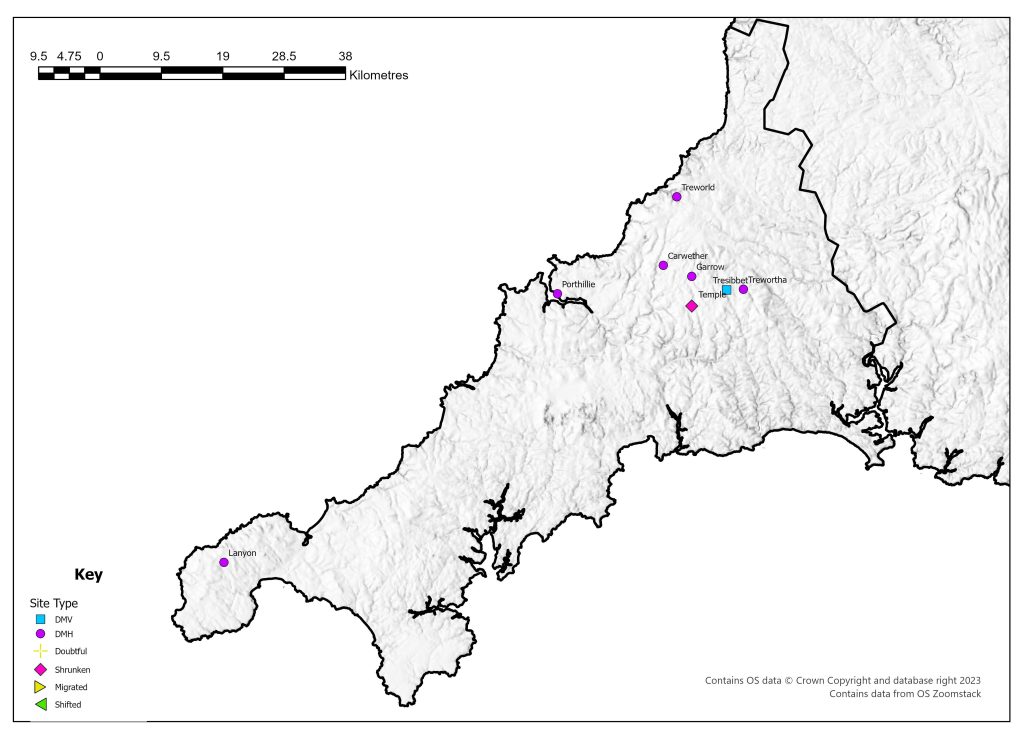
Of the 11 sites identified in 1968, four sites had been excavated by the time of the Gazetteer. Excavations in 1891-2 at Trewortha have been classed as one of the earliest excavations of a deserted medieval settlement, even if it was not identified as such at the time (Baring-Gould 1895a, 1895b). Initially excavated as it was thought to be evidence of prehistoric settlement, the only date that was given by the excavations was post-Roman (Baring-Gould 1895a, 1895b). The excavation revealed the remains of a number of stone buildings, typical longhouses of the area, although a more complex interpretation of a council house was given at the time (Baring-Gould 1895a).
Two individuals excavated at three sites, Dorothy Dudley and E Marie Minter. In 1952 they excavated at Garrow looking at one house which they dated to the thirteenth to fifteenth century (Dudley and Minter 1962-63). Treworld in north-east Cornwall was excavated in 1963. A number of phases of activity were identified, with stone houses suggested from A.D. 1200, but preceding this has been a much debated phase which is suggested to consist of turf houses (Dudley and Minter 1966). In 1964 the site of Lanyon was excavated which revealed stone buildings from the twelfth century (Minter 1965, Beresford 1994).
The RCHME have undertaken detailed surveys of Garrow, Trewortha Marsh and Carwether as part of their survey of Bodmin Moor (Johnson and Rose 1994).
Many of the excavated sites have been concentrated on what has been classed as marginal or secondary sites – areas which have seen settlement expansion (Preston-Jones and Rose 1986: 151). More research is suggested in the lowland areas, the documentary evidence has suggested that at least 750 settlements that are mentioned have since been deserted (Preston-Jones and Rose 1986: 151).
County Boundaries
The boundary of Cornwall has remained very static, with only small parts exchanged with its only neighbour, Devon. It remains as a single administrative county.
Documentary Evidence
The 1334 Lay Subsidy is not complete but has been supplemented with later records (Glasscock 1975). Many of the receipts for the 1377 Poll Tax survive but the record is not complete especially for the Powder and Pyder Hundreds (Fenwick 1998: 80). The records for the county in the sixteenth-century Lay Subsidises are varied in survival (Sheail 1998: 74). The Hundred of East has no records for 1524 or 1525 but a record for 1544 does survive. For a number of hundreds the record for 1524 is missing or fragmentary. For most of the county the later figures are for the 1543 Lay Subsidy but for the Hundreds of East and West they are for 1544. There are no surviving returns for the Diocesan Return in 1563. Many of the settlements recorded in Cornwall do not appear in the documentary record – partly as many are so small that they were probably not individually taxed but included with other settlements.
County Records
Cornwall is serviced by a single HER covering both Cornwall and the Isles of Scilly. Their data can be viewed via Heritage Gateway at. A number of projects have been undertaken making public the information held by the HER – this include a range of aerial photographs that can accessed at the Flying Past website.
References
Baring-Gould, S. 1895a. ‘An Ancient Settlement of Trewortha Marsh’, Journal of the Royal Institution of Cornwall 11: 57-70.
Baring-Gould, S. 1895b. ‘Ancient Settlement of Trewortha’, Journal of the Royal Institution of Cornwall 11: 289-90.
Beresford, G. 1994. ‘Old Lanyon, Madron: a Deserted Medieval Settlement. The Late E Marie Minter’s Excavations of 1964’, Cornish Archaeology 33: 130-169.
Beresford, M.W. 1971. ‘A Review of Historical Research (to 1968)’, in M.W. Beresford and J.G. Hurst (eds.) Deserted Medieval Villages: Studies: 3-75. London: Lutterworth.
Dudley, D. and E.M. Minter 1962-3. ‘The Medieval Village at Garrow Tor, Bodmin Moor, Cornwall’, Medieval Archaeology 6-7: 272-294.
Dudley, D. and E.M. Minter 1966. ‘The Excavation of a Medieval Settlement at Trewold. Lesnewth, 1963’, Cornish Archaeology 5: 34-58.
Dyer, A. and D.M. Palliser 2005. The Diocesan Population Returns for 1563 and 1603. Oxford: Oxford University Press.
Fenwick, C.C. 1998. The Poll Taxes of 1377, 1379 and 1381: Part 1: Bedfordshire-Leicestershire. Oxford: Oxford University Press.
Glasscock, R.E. 1975. The Lay Subsidy of 1334. London: Oxford University Press.
Herring, P. 1998. Cornwall’s Historic Landscape: Presenting a Method of Historic Landscape Character Assessment. Truro: Cornwall Archaeological Unit.
Johnson, N. and P. Rose 1994. Bodmin Moor: An Archaeological Survey Volume 1: the Human Landscape to c. 1800. London: English Heritage.
Minter, E.M. 1965. ‘Lanyon in Madron: Interim Report on the Society’s 1964 Excavation’, Cornish Archaeology 4: 44-45.
Overton, M. 2006. ‘Farming, Fishing and Rural Settlements’, in R.J.P. Kain (ed.) The South West: 109-130. London: English Heritage.
Preston-Jones, A. and P. Rose 1986. ‘Medieval Cornwall’, Cornish Archaeology 25: 135-185.
Rippon, S. and B. Croft 2007. ‘Post-Conquest Medieval’, in C.J. Webster (ed.) The Archaeology of South West England: South West Archaeological Research Framework Resource Assessment and Research Agenda: 195-203. Taunton: Somerset County Council.
Sheail, J. 1998. The Regional Distribution of Wealth in England as Indicated in the 1524/5 Lay Subsidy Returns: Volume One. London: List and Index Society.
List of deserted villages recorded in 1968
Site names in italics are unlocated and so do not appear on the VIllage Explorer. For the unlocated sites, click on their names and it will take you to the basic information about this village.
- Avada
- Carwether
- Garrow
- Lanyon
- Porthillie
- Temple
- Tregrebi
- Trenidered
- Tresibbet
- Treworld
- Trewortha