
Description
In 1954 nine settlements were listed as lost, with a further seven possible sites (Beresford 1954: 346). All appear on the 1968 Gazetteer which numbered 33 in total. One piece of work that was influential in locating sites in Derbyshire was a paper by Wightman (1961) looking at open field agriculture in the Peak District. Mainly in the footnotes to this paper he examines the documentary evidence for a range of deserted villages as well as making the distinction of deserted hamlets. The number of identified deserted settlements has increased with over 60 sites now recorded on the HER.
Derbyshire was traditionally seen as an upland zone, characterised by dispersed settlement. This was the premise tested by Wrightman in 1961 and his main conclusion was that Derbyshire does evidence nucleated villages and open field systems, although little settlement occurred in the highest levels of the Peak District. The East Midlands in general does show that areas of nucleated settlement can sit side by side regions with dispersed settlement, and that regions and counties vary considerably (Lewis 2006).
Excavations
The main excavations that have occurred in the county have been concentrated in the southern areas. Barton Blount was excavated in 1968 due to the threat from deep ploughing (Beresford 1975). This had effectively destroyed the archaeology that was both above and below the surface across a large part of the site. These excavations found five possible phases of expansion due to the layout and grouping of the site, with a date of occupation between the tenth and fifteenth century. The excavations completely investigated four crofts, but there are thought to be about forty-three crofts at the settlement (Beresford 1975). The excavation revealed a variety of timber structures that were never replaced in stone (Beresford 1975). More recent excavations have been small scale such as the excavation of Blingsby village (does not appear on the 1968 Gazetteer), the excavation of part of a building at Derwent and the survey work on the Chatsworth Estate (Beresford 2012, Sidebottom 1993, Barnatt 2009).
County Boundaries
There have been a few amendments to the county boundaries in the past with losses to Staffordshire, Cheshire, the West Riding of Yorkshire and Leicestershire, and gains from Cheshire, Leicestershire and the West Riding of Yorkshire. Today the County of Derbyshire exists with little change from the 1974 county with the exception of the creation of the Borough of the City of Derby.
Documentary Evidence
The 1334 record is complete however a number of places in pre-1974 Derbyshire were recorded in Leicestershire in 1334, and a number of places recorded in Derbyshire in 1334 were in pre-1974 Leicestershire or Staffordshire (Glasscock 1975). There is a very fragmentary record for the fourteenth-century Poll Taxes for Derbyshire with only records for Derby in 1377 and 1379. Only records for High Peak Wapentake survive for 1381 (Fenwick 1998: 95). For the sixteenth-century lay subsidies the records are defective and the later subsidy for 1543/44 is not available (Sheail 1998: 77). The Diocesan Returns survive in the records from the Diocese of Coventry and Lichfield (Dyer and Palliser 2005).
Country Records
The Derbyshire HER covers the entire county can be accessed online via Heritage Gateway.
References
Barnatt, J. 2009. ‘Chatsworth: Archaeological Landscapes and Local Distinctiveness Through Time’, Archaeological Journal 166: 124-192.
Beresford, G. 1975. The Medieval Clay-land Village: Excavations at Goltho and Barton Blount. London: The Society for Medieval Archaeology.
Beresford, M. 2012. The Hardwick Estate: A Journey Through Time. MBarchaeology Unpublished Report.
Beresford, M.W. 1954. The Lost Villages of England. London: Lutterworth.
Dyer, A. and D.M. Palliser 2005. The Diocesan Population Returns for 1563 and 1603. Oxford: Oxford University Press.
Fenwick, C.C. 1998. The Poll Taxes of 1377, 1379 and 1381: Part 1: Bedfordshire-Leicestershire. Oxford: Oxford University Press.
Glasscock, R.E. 1975. The Lay Subsidy of 1334. London: Oxford University Press.
Lewis, C. 2006. ‘The Medieval Period (850-1500)’, in N.J. Cooper (ed.) The Archaeology of the East Midlands: an Archaeological Resource Assessment and Research Agenda: 185-216. Leicester: Leicester Archaeology Monographs 13.
Sheail, J. 1998. The Regional Distribution of Wealth in England as Indicated in the 1524/5 Lay Subsidy Returns: Volume One. London: List and Index Society.
Sidebottom, P. 1993. ‘The Derwent Cross Shaft: Discovery and Excavation 1991’, Transactions of the Hunter Archaeological Society 17: 9-18.
Wrightman, W.E. 1961. ‘Open Field Agriculture in the Peak District’, Derbyshire Archaeological Journal 81: 111-125.
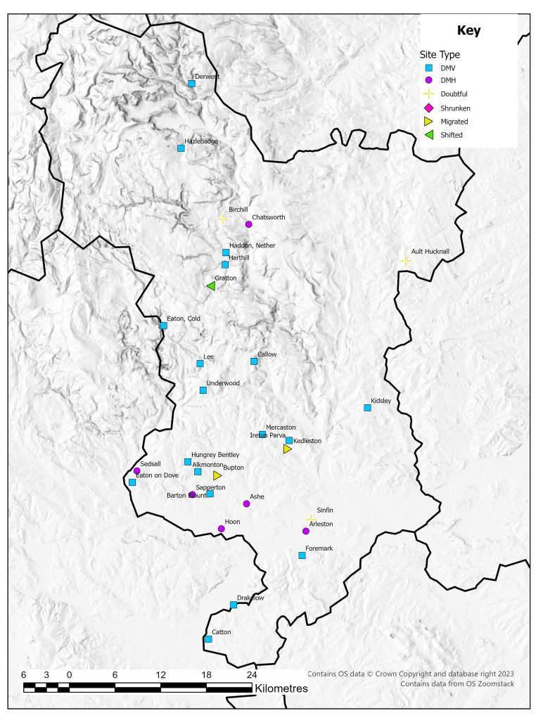
List of deserted villages recorded in 1968
Site names in italics are unlocated and so do not appear on the VIllage Explorer. For the unlocated sites, click on their names and it will take you to the basic information about this village.
- Alkmonton
- Arleston
- Ashe
- Ault Hucknall
- Barton Blount
- Birchill
- Bolun
- Bupton
- Callow
- Catton
- Chatsworth
- Derwent
- Drakelow
- Eaton on Dove
- Eaton, Cold
- Foremark
- Gratton
- Haddon, Nether
- Harthill
- Hazlebadge
- Hoon
- Hungrey Bentley
- Ireton Parva
- Kedleston
- Kidsley
- Lee
- Mercaston
- Sapperton
- Sedsall
- Sinfin
- Tunestalle
- Underwood
- Welledene