
Description
In 1954 Beresford made no real attempt to list sites in Devon, only noting early excavations at Great Beere (Beresford 1954, 347). Devon was one county where much work was being carried out by the 1960s. This benefited the Gazetteer to a certain extent but only 15 sites were listed and it was included within the 15 counties that still needed more research. The reasons for this are unclear as Linehan had published many more sites in 1966. This research though has been regionally specific – for example Dartmoor has received much of the attention. Since the publication of the 1968 Gazetteer there has been much work looking at deserted settlement, continuing the work of Linehan and excavations by Minter. Much of the work has still focused on particular landscapes with much work continuing on Dartmoor and Exmoor. Here Linehan had identified 110 deserted sites, and further sites have been identified since (Linehan 1966, Newman 2011: 130-131). Of these it is suggested that 45 can be seen as medieval settlements abandoned before c.1500 (Newman 2011: 130-131).
The landscape of settlement across Devon is one of a few nucleated villages, many hamlets and isolated farmsteads, and this pattern seems to have a long history (Hall and Hamlin 1976). This is perhaps why Devon has been difficult to quantify in terms of deserted medieval villages as many settlement sites fall into much smaller categories. However the landscape does differ on a regional basis, with significantly different patterns even in neighbouring parishes (Turner 2006: 5, Overton 2006: 109). The settlement form in Devon also varies, and many of the deserted sites consist of a cluster of buildings, sometimes with their own yards, but not the format of toft and croft seen in central England.
The reasons for desertion in Devon have been discussed and argued about in detail (Newman 2011). As an area where the raising of stock was always important, the impact of the change from arable, seen in other areas of the country, was not felt here (Hall and Hamlin 1976). Many have suggested that soil exhaustion was a likely cause of desertion (Beresford 1979). However the blame has often been laid at the door of climate change (Hall and Hamlin 1976). However on Dartmoor there are a number of settlements that do not become deserted until much later and the story of settlement desertion is complex (Newman 2011).
Excavations
Devon saw one of the very first scientific excavations carried out at a deserted settlement when the site at Beere was investigated in 1938-39 (Jope and Threlfall 1958). They excavated one house, one barn and two corn-drying kilns as well as trial trenching a number of other structures. The house was described as a typical longhouse as was one of the first where a full plan was revealed in the area (Jope and Threlfall 1958: 112).
Excavations had also been carried out on a number of sites by E. Marie Minter who had also worked in Cornwall with Dorothy Dudley. She excavated at Houndtor, Hutholes and Dinna Clerks on Dartmoor, however they were published posthumously and in the absence of any draft text for the final report (Beresford 1979). These excavations revealed a complex development of house structures and a suggestion that two periods of construction could be identified – the first with turf houses followed by stone-built houses (Beresford 1979). This has been debated which will be discussed below.
Houndtor is a site now in the guardianship of English Heritage and was one of the first sites to be protected at the behest of the Deserted Medieval Village Research Group. The walls of structures could be clearly seen during the winter months when the vegetation was low (Beresford 1979: 98). The entire settlement was excavated and the conclusion was drawn that the stone built houses were most likely thirteenth century in date, and that the numerous earlier phases of turf structures could date the earlier phases back to the eight century (Beresford 1979: 146). Similar patterns were also suggested for Hutholes and Dinna Clerks. This Anglo-Saxon origin of the settlement has been challenged (Austin and Walker 1985, Austin 1985). The early turf buildings identified from stake holes have been identified as possible temporary sub-divisions in the stone buildings and thus negating an early phase of activity (Austin 1985: 71).
Beresford responded to these ideas suggesting the best example of the turf houses can be found at Hutholes with stake holes running under the footings of a stone building, which was confirmed in 1977 (Beresford 1988: 178). A re-excavation of a longhouse at Hutholes in 1994 revealed no evidence for the stake holes or turf houses and concluded the primary structure at the site was the stone building (Gent 2007).
One issue with the early excavations in Devon (and Cornwall) was the lack of established typologies for the local medieval pottery, and the limited amount recovered during excavations (Beresford 1979: 146). This made dating often only a tentative suggestion. Houndtor produced some pottery that was perhaps twelfth century in date, Hutholes and Dinna Clerk were suggested to be aceramic until the thirteenth century (Beresford 1979: 146). Since this point in time, some of the pottery has been lost, but some relocated and so assessment can be made of this earlier material (Allan 1994). A typology has now been produced and it suggested that none of the excavated settlements on Dartmoor had produced pottery that was dated before c. 1200 and that there is no evidence the excavated sites were occupied after 1450 (Allen 1994: 145).
One area where deserted settlements were listed by Linehan in 1966, and where subsequently fieldwork has been carried out, but none of the settlements making the 1968 Gazetteer, is Okehampton Park. Excavations in the late 1970s investigated one of the sites, and further survey work has been carried out by English Heritage since the 1990s (Austin 1978, Austin et al. 1980). Across the area of Okehampton Park a number of small clusters of buildings have been identified strung-out across the landscape (Newman 2011: 135).
Further areas such as Challacombe have been subjected to extensive field survey and detailed plans of not only the settlements published but also the associated field systems (Pattison 1999).
County Boundaries
There have been small changes to the boundary of Devonshire with exchanges with Cornwall to the west and Dorset and Somerset to the east. Devonshire is now divided into the county of Devon and the unitary authorities of Plymouth and Torbay.
Documentary Evidence
The 1334 list of particulars for the Lay Subsidy is not extant but the 1336 list is used in its place as it has been shown to be based on the figures from 1334 (Glassock 1975). Two places in pre-1974 Devon were recorded in Dorset in 1334 (Glasscock 1975). For the 1377 Poll Tax a number of records survive but for some hundreds only the final total paid is recorded and not the amount for the individual settlements (Fenwick 1998: 114). No detailed rolls for 1379 or 1381 survive. For the sixteenth-century lay subsidies caution has been noted for some of the records (Sheail 1998: 79). The available records for the later subsidies are either 1544 or 1545 (Sheail 1998). There are no surviving returns for the Diocesan Return of 1563 (Dyer and Palliser 2005). Many of the settlements recorded in Devon do not appear in the documentary record – partly as many are so small that they were probably not individually taxed but included with other settlements.
County Records
There are different HERs for each modern-day divisions of the county as well as the Dartmoor and Exmoor National Parks. The data for Devon, Exmoor and Dartmoor can be accessed via Heritage Gateway. The records for Plymouth and Torbay are currently not available online.
References
Allan, J. 1994. ‘Medieval Pottery and the Dating of Deserted Settlements on Dartmoor’, Proceedings of the Devon Archaeological Society 52: 141-148.
Austin, D. 1978. ‘Excavations in Okehampton Deer Park, Devon, 1976-1978’, Proceedings of the Devon Archaeological Society 36: 191-239.
Austin, D. 1985. ‘Dartmoor and the Upland Village of the South-West of England’, in D. Hooke (ed.) Medieval Villages: 71-79. Oxford: Oxford Committee for Archaeology.
Austin, D. and M.J.C. Walker 1985. ‘A New Landscape Context for Houndtor, Devon’, Medieval Archaeology 29: 147-152.
Austin, D., R.H. Daggett and M.J.C. Walker 1980. ‘Farms and Fields in Okehampton Park, Devon: the Problems of Studying Medieval Landscape’, Landscape History 2: 39-57.
Beresford, G. 1979. ‘Three Deserted Medieval Settlements on Dartmoor: A Report on the late E. Marie Minter’s Excavations’, Medieval Archaeology 23: 98-158.
Beresford, G. 1988. ‘Three Deserted Medieval Settlements on Dartmoor: A Comment on David Austin’s Reinterpretations’, Medieval Archaeology 32: 175-183.
Beresford, M.W. 1954. The Lost Villages of England. London: Lutterworth Press.
Dyer, A. and D.M. Palliser 2005. The Diocesan Population Returns for 1563 and 1603. Oxford: Oxford University Press.
Fenwick, C.C. 1998. The Poll Taxes of 1377, 1379 and 1381: Part 1: Bedfordshire-Leicestershire. Oxford: Oxford University Press.
Gent, T. 2007. ‘The Re-Excavation of a Deserted Medieval Longhouse at Hutholes, Widecombe-in-the-Moor, Dartmoor’, Proceedings of the Devon Archaeological Society 65: 47-82.
Glasscock, R.E. 1975. The Lay Subsidy of 1334. London: Oxford University Press.
Hall, J. and A. Hamlin 1976. ‘Deserted Medieval Settlements in Devon’, The Devon Historian 13: 2-7.
Jope, E.M. and R.I. Threlfall 1958. ‘Excavation of a Medieval Settlement at Beere, North Tawton, Devon’, Medieval Archaeology 2: 112-140.
Linehan, C.D. 1966. ‘Deserted Sites and Rabbit Warrens on Dartmoor, Devon’, Medieval Archaeology 10: 113-144.
Newman, P. 2011. The Field Archaeology of Dartmoor. Swindon: English Heritage.
Overton, M. 2006. ‘Farming, Fishing and Rural Settlements’, in R.J.P. Kain (ed.) The South West: 109-130. London: English Heritage.
Pattison, P. 1999. ‘Challacomb Revisited’, in P. Pattison, D. Field and S. Ainsworth (eds) Patterns of the Past: 61-70. Oxford: Oxbow Books.
Sheail, J. 1998. The Regional Distribution of Wealth in England as Indicated in the 1524/5 Lay Subsidy Returns: Volume One. London: List and Index Society.
Turner, S. 2006. ‘The Medieval Landscape of Devon and Cornwall’, in S. Turner (ed.) Medieval Devon and Cornwall: 1-9. Macclesfield: Windgather.
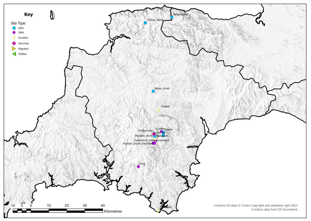
List of deserted villages recorded in 1968
- Badgworthy
- Beere, Great
- Blackaton
- Bolt Head
- Challacombe
- Cordonford, Little
- Corndonford
- Cripdon
- Ford
- Hayne
- Hound Tor
- Rowden, North
- Rowden, South (Hutholes)
- Thorne, North
- Treable