
Description
In 1954 Beresford lists 13 clearly identified sites as well as listing a range of decayed churches (Beresford 1954: 347-349). In the 1968 Gazetteer, 42 settlements are listed. There are notes in the Medieval Village Research Group Annual Reports from late 1980s of a Dorset county list of deserted and shrunken settlements being compiled. In 1988 it was noted the list totalled 254 separate sites (Higham 1988: 15). Since this point there has been continuing work on deserted settlements in the county. A good summary of ‘Lost Villages’ was published by Ronald Good in 1979. This divides settlements into various groups: those classed as deserted villages (43 sites); those now represented by country houses (26 sites); those represented by farmsteads (90 sites); existing villages which have changed (31 sites); and villages submerged by modern buildings (47 sites) (Good 1979). The total list of settlement reaches 237 excluding a complex landscape of settlements at Milborne St Andrew, an increase of 195 since 1968.
One clear source for the study of the landscape of Dorset has been the volumes published by the RCHME which reviewed known earthwork remains. This has provided an excellent corpus of surveys published between 1952 and 1975.
Unfortunately Dorset does not feature heavily in recent reviews of medieval settlement in the South West (e.g. Rippon and Croft 2007). One reason for this may well be due to its variety. The pattern of settlement in medieval Dorset is not a unified picture and hence generalities are difficult to tease out. As Taylor noted ‘It is the variety of landscape in Dorset which gives the county its great charm and which has resulted in the equally varied landscape history’ (1970: 21). In places the chalklands take on a more nucleated pattern with villages and open fields, in other areas such as the heathland, a dispersed pattern of farmsteads and enclosed fields prevails (Taylor 1970). The divide between the Central Province and South East province identified by Roberts and Wrathmell cuts through Dorset following very much this geological divide (Roberts and Wrathmell 2000). Much of the early identified deserted settlements have been found in the chalklands, and there is little evidence outside of this zone (Taylor 1970). In some cases clusters of deserted settlements can be seen along chalk valleys. However more recent work and re-evaluation of the definition of settlement may well change this picture.
Excavations
The village at Holworth was excavated in 1958 by Philip Rahtz using open area methodology. This allowed the ephemeral remains of the structures to be identified. A trial excavation in 1936 had already uncovered pottery and stone work. One of the seven clearly defined tofts formed the focus of attention in 1958 (Rahtz 1959). This uncovered pottery dating from the twelfth to the fifteenth century and a longhouse was revealed that was divided into three parts with rubble floors. Only small scale test pitting has been undertaken at the other sites in Dorset such as Bexington and Blackmanston.
County Boundaries
Dorset has seen some small boundary changes with Devon, Hampshire and Somerset. It now is the County of Dorset and the Unitary Authority of Poole. The area of Bournemouth and Chichester were part of Hampshire up to 1974, but are now part of Dorset.
Documentary Evidence
The 1334 record is not complete and has been supplemented with the 1336 data which is based on the 1334 assessment (Glasscock 1975). In 1334 some places listed in Dorset have since moved to pre-1974 Devon and some places now in pre-1974 Dorset were taxed in 1334 in Devon and Somerset (Glasscock 1975). There are no surviving records of the 1377 Poll Tax, and the 1379 and 1381 records are very fragmentary (Fenwick 1998: 145-146). The survival of the sixteenth-century lay subsidies is not complete with only a few hundreds having records for the three different subsidies (Sheail 1998: 84). A mixture of survey dates have been used for the figures in the 1540s with dates of 1543, 1544 and 1545. There are no surviving Diocesan Returns in 1563 (Dyer and Palliser 2005). The Hearth Tax assessments are available for 1662 or 1664 (Meekings 1951). One good antiquarian source of village history that does note deserted settlement is John Hutchins’ ‘The History and Antiquities of the County of Dorset’, first published in 1774.
County Records
Dorset is served by a single Historic Environment Record based with Dorset County Council and the data can be accessed via Heritage Gateway.
References
Beresford, M.W. 1954. The Lost Villages of England. London: Lutterworth.
Dyer, A. and D.M. Palliser 2005. The Diocesan Population Returns for 1563 and 1603. Oxford: Oxford University Press.
Fenwick, C.C. 1998. The Poll Taxes of 1377, 1379 and 1381: Part 1: Bedfordshire-Leicestershire. Oxford: Oxford University Press.
Glasscock, R.E. 1975. The Lay Subsidy of 1334. London: Oxford University Press.
Good, R. 1987. The Lost Villages of Dorset. Wimborne: The Dovecote Press.
Higham, N.J. 1988. ‘Research in 1988. i. Fieldwork’, Medieval Settlement Research Group Annual Report 3: 14-18.
Meekings, C.A.F. 1951. Dorset Hearth Tax Assessments 1662-1664. Dorchester: Dorset Natural History and Archaeological Society.
Rippon, S. and B. Croft 2007. ‘Post-Conquest Medieval’, in C. Webster (ed.) The Archaeology of South West England: 195-207. Taunton: Somerset Heritage Service.
Roberts, B.K. and S. Wrathmell 2000. An Atlas of Rural Settlement in England. London: English Heritage.
Rahtz, P.A. 1959. ‘Holworth, Medieval Village Excavation 1958’, Proceedings of the Dorset Natural History and Archaeological Society 81: 127-147.
Sheail, J. 1998. The Regional Distribution of Wealth in England as Indicated in the 1524/5 Lay Subsidy Returns: Volume One. London: List and Index Society.
Taylor, C. 1970. Dorset. London: Hodder and Stoughton.
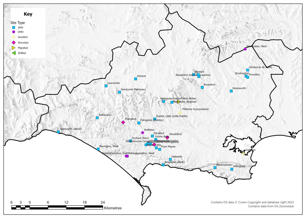
List of deserted villages recorded in 1968
Site names in italics are unlocated and so do not appear on the VIllage Explorer. For the unlocated sites, click on their names and it will take you to the basic information about this village.
- Afflington
- Bexington, West
- Blackmanston
- Brockington
- Bryanston
- Frampton
- Frome Belet
- Fryer Mayne
- Gotowre
- Hanford
- Hemsworth
- Holnest
- Holworth
- Knowlton
- Lazerton
- Lewcombe
- Mayne, Little
- Melcombe Horsey
- Melcombe, Bingham
- Milborne Symondeston
- Milton Abbas
- Orchard (Rew)
- Polingston (Pulston)
- Puddle, Little (Little Piddle)
- Ringstead (West)
- Selavestune
- Shilvinghampton, East
- Shilvinghampton, West
- Slitlege
- Stanton St. Gabriel
- Steepleton Iwerne
- Stinsford
- Whitcombe
- Wimborne All Saints
- Winterbourne Came
- Winterbourne Farringdon
- Winterbourne Herringstone
- Witherston
- Wolfeton
- Woodsford
- Woodyates, West
- Woolcomb Maltravers